
Dubois, WY to Lander, WY: the Wind River Range
Gunsight Pass is a portal. After a few days of hot and dry rolling hills, brush and scrub, a climb above 10,000 feet yields a SoBo’s first views of the Wind River Mountain Range. I hit it at sunset and anticipation swelled in my heart. I set up camp next to a spring on less than even ground. Smokey passed by about a half hour later, night hiking, and elected to go another mile or so down to the Roaring Fork bridge. Moments later, the bag I was cooking my dinner in sprung a leak. Now, I’m not bearanoid, but I’d rather not sleep atop a puddle of food, so I packed up and headed down to the bridge. I’m glad I did; also camped there were the Liverstrongs, aka SOGO and Julieangelo, with whom I finished the PCT in 2014.
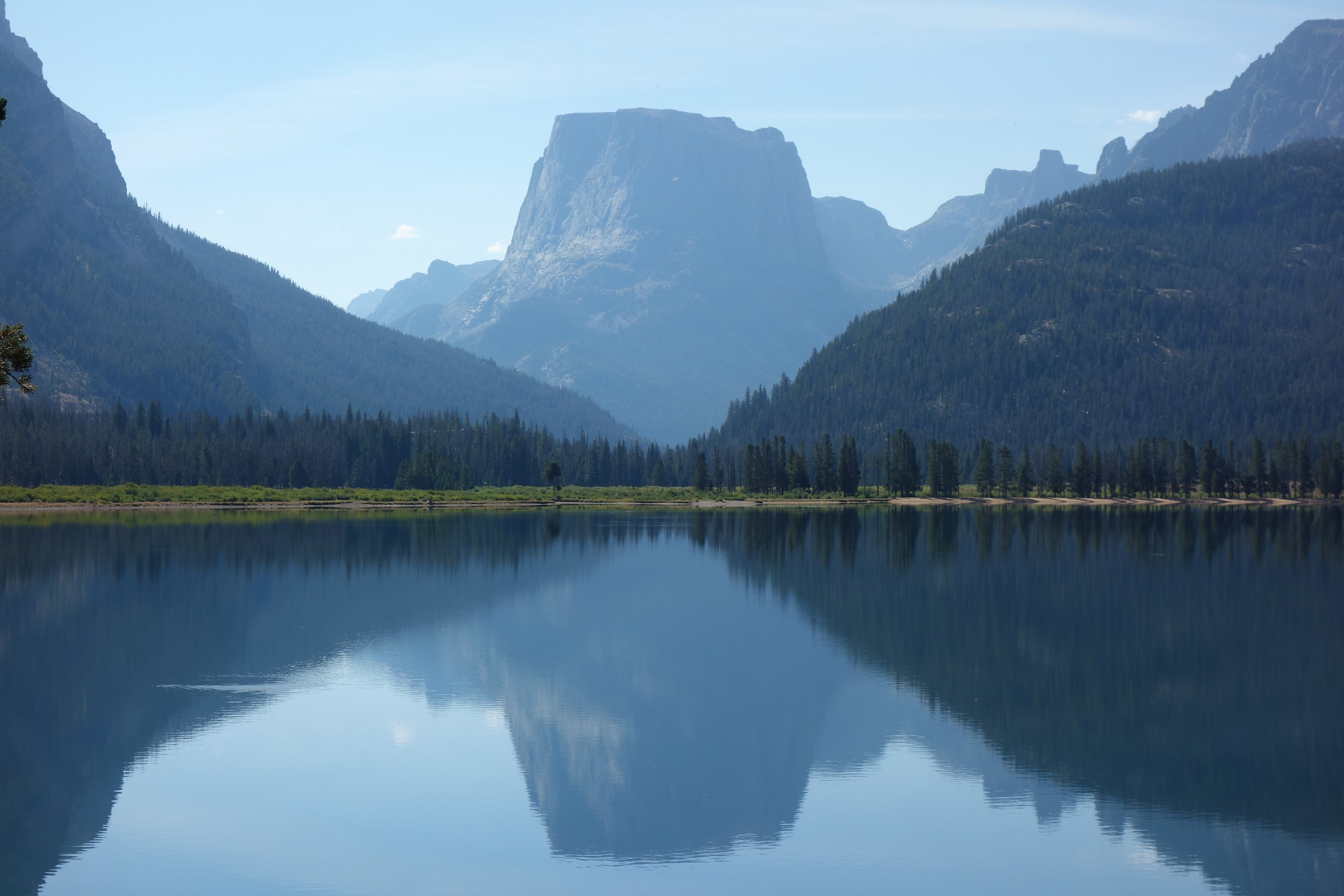
The next morning the trail dumps you out at the foot of the first of the Green River Lakes. This valley is idyllic as all get-out; at first glimpse of Squaretop Mountain reflecting off the turquoise water I was in love. I hiked along the shore of the lake with a grin plastered on my face. With each step, the mountains loomed higher, the hue of the water deepened and glowed, and the canyon walls simultaneously softened into wind carved billows and fractured into jagged chess piece crowns. Just shy of the last Green River crossing before going up and over Green River Pass, I came upon Bright Eyes and Sadie having a snack. I hadn’t seen them since Mack’s Inn, but cut the conversation short on the grounds that I desperately needed to immerse myself in that rushing turquoise water.

Those two and Smokey caught me in the evening, a few miles into an alternate route that leads up and over Knapsack Col along the Wind River High Route, eating my dinner with a mother and daughter from Alaska who were hiking from Pinedale to the Green River Lakes trailhead. As the sun dipped behind the massive range that beckoned just ahead, Smokey and I made our way up a long talus chute to Peak Lake. I laid down in my tent eager to wake up to the surely sublime alpine enclosure we’d scrambled into.

Peak Lake
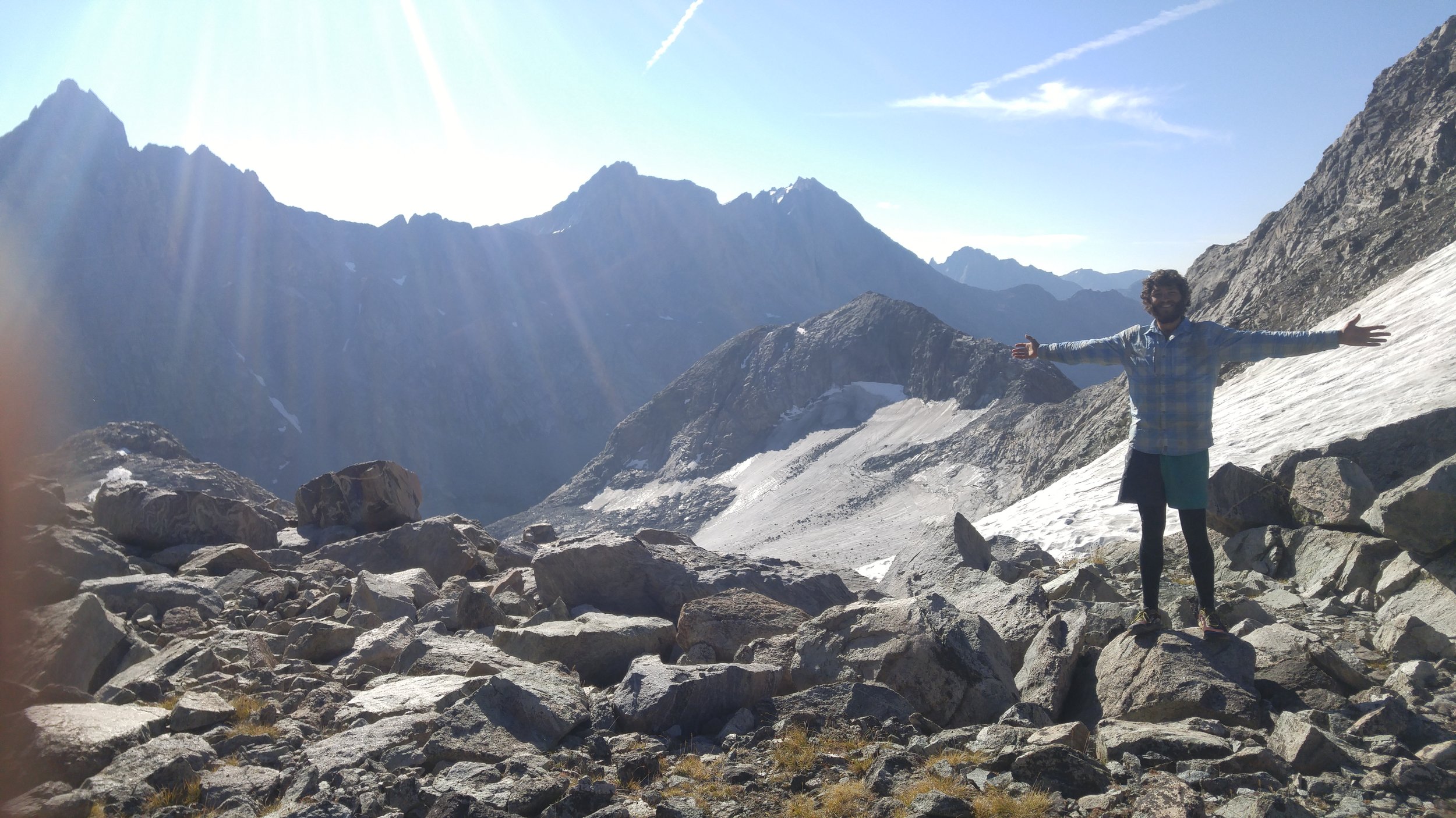
Knapsack Col is a trek. (A col is a notch or a saddle. Don’t worry, I spend months at a time in the mountains and I still had to Google it). At about 12,200 feet up, Knapsack is flanked by glaciers, which, despite rapid recession, still birth the mighty Green River, which in turn feeds the Colorado. I had tears in my eyes going up this arduous boulder scramble of a climb, and I eagerly chugged a couple liters of unfiltered glacial melt as I drank in the beauty that shone from all directions. At the top, after a much needed snack break, Smokey informed me we’d accomplished less than three miles of travel and it was nearly ten. Time to hustle.

The descent from Knapsack into the Titcomb Basin was even sketchier than the ascent – loose talus threatening long falls onto unfriendly crags with damn near every move. This would have been far more frustrating if not for the famous basin and its namesake lakes waiting at the bottom.
Though I’d been bundled up for the climb that morning, I shed all my base layers once down at lake level. The sun was strong at this elevation, uninterrupted by clouds, and I started keeping an eye out for a spot free from view of the many campers exploring the basin so that I might take a quick skinny dip. Of course, the water would still be pretty cold, so I was also being picky about finding a place from which I could jump into the water, be fully submerged, and climb immediately out. This took a long time. Titcomb Basin was exponentially more crowded than any part of the CDT yet, excepting the National Parks.

Knapsack took a lot out of Smokey and me, and adding a couple more passes to that all in a thirty mile day didn’t help. The next day was slow going, and when I hit the junction for the Cirque of the Towers alternate, considered the jewel of the Winds, I was unsure whether I’d take it or not. A gnarly thunderstorm was brewing just south of me and Smokey was nowhere to be seen. I wasn’t sure I wanted to be far above tree line, alone, nor was I sure I’d be able to make it to Lander on time Saturday if I added in all the extra elevation gain (ah yes, yet another section of hurry-up-to-the-Post-Office… all so I can use this laptop). However, once Smokey rolled up, I was resolute: I was not going to miss the Cirque.

There were a few folks camped at Shadow Lake, and more than one guy expressed surprise that we’d go over Texas Pass this late in the evening. Yep, we thru-hikers, full of surprises. The approach to Texas Pass was stunning: all the lakes are crystal clear mirrors for what were easily the most dramatically carved and imposing peaks of the trail up to that point and as we trudged up the loose gravelly incline, a warm alpenglow sidled up to retreating thunderheads. The climb was objectively easier than Knapsack, but we were exhausted and by the time we reached the pass, the sun had already gone down. No problem: we camped just below the pass and woke to a sunrise across Pingora Peak and Wolf’s Head that I’ll never forget.

We descended to Lonesome Lake and I ended up on a side trail by mistake. While bushwhacking back to the trail, I turned a corner and came face-to-face with a hefty bull moose laying in the undergrowth. I slowly backed up, looking slightly away from him, as he sprung to his hooves. Despite the sudden movement, he seemed completely at ease, so I followed suit and relaxed. We eyed each other for a good while, and once he lay back down I made my way – widely – around him back to the trail.

Up and over Jackass Pass and my legs were feeling leaden. These mountains are no joke, especially after a few sections of easygoing terrain through northern Wyoming. After eating lunch and hiding from the wind beneath Temple Peak, the CDT offers respite with a long, downhill jaunt through the massive canyon cut by the now modest Little Sandy Creek. The creek pools into Little Sandy Lake, at which there is a trail junction. Only seventeen miles into the day, according to Ley (so probably more like twenty-plus…), I reached the lake at 5:30. Yikes. Still about thirty miles to the highway, from which Lander is a 36 mile hitch to the northeast.

Fortunately, the sun stayed up long enough for Smokey and me to descend from the real timber and mountains to that liminal space before the lowlands and sagebrush. Night found us walking along a dirt road, admiring the clarity of the sky. We trudged along, beaten and exhausted, until about midnight and camped at a BLM campground. Something like sixteen miles from the highway, we elected to cowboy camp and wake up at 4:30 in order to give me the best chance of getting to Lander in time to pick up my box – Smokey was on a time crunch of his own, but that’s a whole different story.
I woke at the sound of Smokey’s voice: “Ah shit.” Rain. I asked what time it was, figuring it may be worth just packing up and hiking, but it was only two in the morning. We both scrambled to set up our shelters and I crawled back into my bag for a few meager hours of fitful, damp sleep. We were hiking before sunup.
That morning I saw my first pronghorns, though they were so far off and quick moving that I wasn’t quite sure what I’d seen at first. Smokey and I were both in a pretty sorry state but refused to stop for a break. In the end, it was all worth it: I got to the post office with an hour to spare.
As always, lots more photos at Facebook.com/HikeTheDivide and on Instagram; @HiketheDivide