
Drier Climes, Road Walks and Cattle: Roger's Pass to MacDonald Pass
Day 21: It’s fairly rare to thru-hike a long trail without hitchhiking at least once. There aren’t all that many towns built atop the Continental Divide, you know, so sometimes the trail crosses a remote dirt road that happens to be the only access point to a town for say, 80 miles. All you can do is stick a thumb out and hope beyond hope for an old pickup to rattle over the hill and take pity on your stinky, sunburnt self.
The hitch to Lincoln is only 18 miles – but from there, it’s another 79 to Missoula. I had hoped to line up a ride in advance back to Roger’s Pass for the four of us, but the one person who offered had already gone above and beyond with generosity for us so we refused to take them up on it. Time to dust off those thumbs.
Recon, Space Milk, Toppy and I tromped through town with our packs over to the I-90 on-ramp and put on our friendliest smiles. About 40 minutes passed, at least 20 cars per minute along with them. Lots of people gave us thumbs up or any number of indiscernible hand gestures that didn’t seem outwardly negative or particularly encouraging. People do weird things when they see hitch hikers, what can I say.
Of course, the friend who had offered us a ride in the first place came riding up on a mountain bike. “Is this even possible? You should have called me!” Ah, well.
Not five minutes later a midsize SUV pulled over without even taking a second look at us. He said he could take us to Bonner, twenty miles up, where I-90 meets Highway 200: the road to Lincoln. We explained that we were thru hikers and he shared with us that he’s been a lifelong alpinist and has the first ascent of a certain route up Denali, the tallest mountain in North America. Let’s just say there aren’t many people who can claim that honor.
From the spot he dropped us at, we didn’t even have to wait five minutes to get picked up. This guy wanted to talk mostly about Spartan Races, in which he seems to be a fierce competitor, but he also shared a lot of knowledge with us about Montana’s rainfall patterns, overfishing, invasive and noxious plants, wildfires and wildlife. He wasn’t going all the way to Lincoln but he dropped us at a major highway junction and wished us luck.
There was a watercraft check station, RV dumping station and Conoco filling station and convenience store at this junction. Had to grab some snacks. We chatted to a few folks at the gas station but no one seemed to be going our way, so we hopped back over to the road. Recon made a sign out of his Tyvek ground sheet that read “Hikers to Lincoln,” but the last “n” was backwards. Not sure whether that helped or hurt our cause. We told him he should have written “It’s my birthday,” which it was!
After about a half hour of standing in the heat a really old white pickup drove passed us and gave a double take. A few minutes later he came back the other direction and flipped a U in the gas station parking lot, waved us over.
“I’m going to Lincoln, but I have to make a few stops so it’ll take a little longer than usual,” he said, and introduced himself as James. We couldn’t care less about the delay, as long as we got there that afternoon, so we hopped into the bed of the truck, which was full of crushed Diet Dr. Pepper and Icehouse cans, a length of rusty fencing, a gasoline can and a few bags of garbage. Riding in the back of a pickup going 80 on the highway is a world of difference from hiking between two and four miles per hour, and I loved every second of it; doing so will make you appreciate why dogs stick their heads out the windows of cars.
We stopped out front of the “famous” Trixi’s Bar in the little town of Ovando. There’s a sign between Ovando and the highway that reads: “OVANDO is OPEN.” It ain’t a big place. Turns out James works at Trixi’s and just needed to make a phone call. Next stop was the refuse center, aka the dump.
“We call this the Ovando Mall,” he said, as another local offered him a handsaw he found in case anyone he knew was into painting landscapes on them. James didn’t know anyone, but the other man said he knew a lady who 'painted them up real nice', so he tossed it casually into the bed of his spotless new pickup.
“You stay out of trouble, James,” the older man said.
“Yeah or maybe I just won’t get caught,” James said.
We took a different dirt road back to the highway. James slowed to a stop just before a cattle guard and leaned his head out the window: “Just checking, would y’all like to jump in the river real quick or should I just continue on to Lincoln?” It was hot, but we were trying to at least make a few miles before the sun went down so we declined.
James dropped us in Lincoln, where we reconnected with Anchor and Laugh Track. They’d had a pretty adventurous weekend themselves, including a stay in a reportedly haunted hotel room – the only vacant room left in town for the weekend. We hung out in the shade behind a drive up coffee stand and filled each other in with stories of food we ate, blisters popped etc. Eventually we worked up the will to attempt one final hitch for the day.
Hitching with six people is not always the best approach to getting a ride. Fortunately, truck beds have lots of capacity. A couple guys were happy to take us up to the pass as long as we didn’t mind riding in the bed, so off we went. By the time we had feet on trail again, it was nearly five in the evening. It was still sweltering, and we had 1300 feet to climb right off the bat.
Just when we came over the crest of the ridge and left the highway behind, I saw a dog up ahead. “Bright Eyes! Sadie!” Bright Eyes and Sadie hiked the PCT the same year that LT, Toppy, Anchor and I did; Sadie is a magnificent mutt and Bright Eyes is her human.

Sadie embodying the constant physical and emotional state of thru hikers
We all ate dinner together as the sun went down and celebrated Recon’s birthday with the gifts of gummi worms and a single beer packed out by Laugh Track. There was a full moon rising so we decided to push on a few more miles in the light. LT and Anchor hiked ahead and the rest of us found a nice flat bald with an expansive view to set up camp on. It was so clear, breezy and dry that we all decided to cowboy camp (i.e. sleep without a tent), and I decided to do as many CDT hikers do and sleep with my food rather than hang it. Fingers crossed.
Day 22: First thing in the morning Space Milk said he was pretty sure there was a bear poking around the underbrush up the hill from us in the middle of the night – something big moving rocks around, anyway. So much for sleeping with my food.

Just two miles down trail we reached Flesher Pass, where a Lincoln local has been caching water for hikers to alleviate the twenty eight mile waterless stretch. He also left a plastic Folger’s can full of candy. Leaving food unattended in the wilderness is not a good practice, but I’d be lying if I said I wasn’t stoked to see it and that I didn’t grab a pack of Mike n Ike right after filling up a few liters of water…
As the day rolled on the heat rose and the aridity of the air really sunk in; looking around I thought I could have been anywhere, maybe back in northern California on the PCT. After traversing some big ridge walks looking out on massive valleys, all of which looked mighty beige, prickly and hot, we reached Stemple Pass. At Stemple we found another cache of water from the same person, but this time the Folger’s can was empty. Dirt, the pensive super hiker I had met and camped with way back at Red Eagle Lake in Glacier Park, had left a note in the trail register, explaining that he had removed all the snacks as a Folger’s can is not bear or critter safe. He also offered his sincere apologies. I respected this move quite a bit. For one, Dirt does not seem at all to be the kind of person who would take all the goodies for his own enjoyment – rather, he truly was doing what he saw as right. He had to have known that people would throw a fit (they did, on the CDT Southbounders Facebook group…), and that people would be disappointed to find an empty vessel where once trail magic was stashed. Big ups, Dirt, way to stick to your morals and uphold LNT (that is, Leave No Trace ethics).
To be honest I can’t remember exactly when this happened, but I feel it was this day, so here we go. Crossing a little bald, we met our first NoBos (exactly the opposite of SoBos, of course!). Their names are Whitefish and MT (or perhaps Empty?) Bighorn, and they definitely looked like they’d been on trail for over 2000 miles. MT Bighorn had a gun strapped across his chest – the first thru hiker I’ve ever seen carry a gun – and I was not surprised at all to hear they were both from Montana.

They had begun the trail on March 23rd, which is early by any standard, and had hit heavy snow in Colorado. They had to take the Creede Cutoff around the San Juan Mountains, and had, in their words, “snowshoed from Mt. Taylor, NM to Rawlins, WY.” They also admitted that they “yellowblazed” (hitch hiked in order to skip a section) the Anaconda Route, which already shaves off 90 miles of trail. So, while you can’t really say that this pair was going to be the first to finish the CDT this year, you can’t say they haven't been absolutely crushing miles in tough conditions. Side note – some people refer to the frontmost hiker as “winning the CDT”; others, myself included, are of the opinion that it’s the last hiker to Canada or Mexico who wins. The way I see it, the goal is to spend the most time in the mountains as possible, not to be the fastest hiker, to break records, to impress people etc.
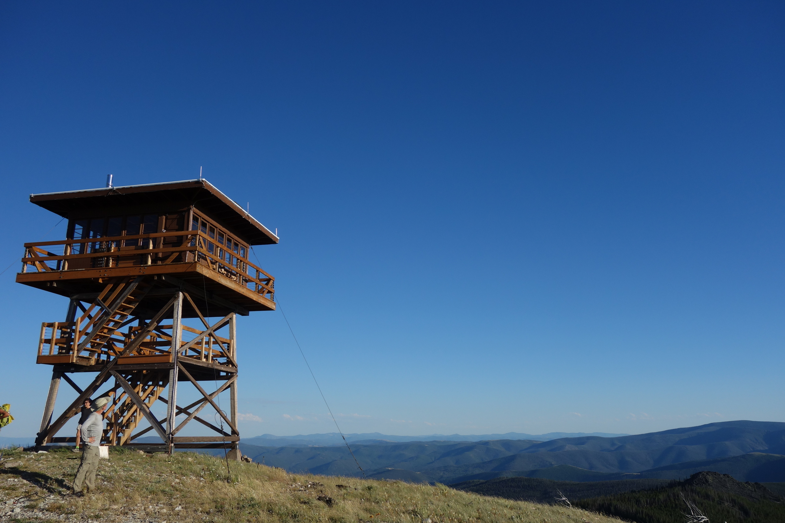
Later in the day we crested a hill and saw a fire lookout tower up on a ridge, behind which you could see the valley in which Helena and the Missouri River can be found. The hill the tower was set upon had been torched by a wildfire in recent years, and the burn scar stopped what looked to be no more than two hundred feet from the tower – lucky break!

This could have gotten real ironic real fast
Here there was a route choice; one way takes you up over the ridge past the fire lookout and over Granite Butte, and the other skirts that climb and leads you to a spring. Well, if not for those two water caches, the spring would be the first reliable water source in 28 miles, so despite having gotten some hydration at the passes, the low route was an easy choice. The water spurted right out of the ground, cool and clear. Recon, Top Shelf, AquaCam and I sat there on a dirt road cooking our dinners so we wouldn’t have to lug any more water than necessary, and were very much surprised when a huge van and mid-size SUV pulled right up to us.
Two women, Barb and Karina, and a slew of mutts greeted us and recognized us as CDT hikers. Now, this is not the Appalachian Trail – a good amount of people I’ve run into, even literally on the trail, don’t even know about CDT thru-hikers, so it’s always nice to meet folks who are aware of this crazy endeavor we’ve taken upon ourselves. They were heading up to spend the night at the fire lookout, the restoration of which they had been integral to, and offered to shuttle us up there to check it out. Score. We piled in back of the van, dinners in hand and real cozied up with the dogs.
Recon taking it all in
The lookout hasn’t been used since 1977, and apparently needed a lot of love, but thanks to lots of volunteer hours, it is available for rent as of August 1st. It’s a beautiful structure, and the views are, naturally, hard to beat. You can see both Lincoln and Helena from up top, and I could see most of what my next few days of hiking would entail.

After getting a proper tour of the tower, Barb took us back down to the spring where she had found us. Right as we turned the last corner we ran into Bright Eyes and Sadie, who were walking the wrong way. After the initial bewilderment of seeing us in back of a van in the middle of nowhere, Bright Eyes admitted she was glad to see us, as she’d been having a rough day. We showed her the little game trail to where the spring was hidden and waited for her to fill up before continuing southward a few more miles before setting up camp in the one flat spot we could find – right beneath a bunch of widow-makers (i.e. dead trees just barely standing or that are being supported by other trees, which are often dead as well).
Day 23: 35 miles to Helena. Generally, the goal is to do as few miles as possible on a day you’re heading into town, so that you can maximize the time you have to complete your chores, stuff your face, and actually sit still for once. The four of us figured we were just behind Anchor and Laugh Track, and that we’d be able to do somewhere around 25mi on the day to put us in chipping range to the highway.
The morning had a big steep climb up Black Mountain just waiting for us. Of course, we hit it just as the heat began to kick in.

The Pacific Crest Trail has an average grade of 6%; it’s a running joke (well, half-joke) to whine when the PCT is steeper than 6%, and to say “this is NOT PCT grade!” Well, I think that I’ve said that phrase at least a hundred times on this trail so far, and it’s just the beginning. The climb up Black Mountain was a gnarly skree slope with hardly any switchbacks and next to no shade. At the beginning of the climb we ran into yet another northbound hiker, an older fellow named HoB: “Hiking or Biking.” HoB had skipped Colorado to bypass the snow and will be returning to hike it after he reaches the Canadian border.
The trail descends from Black Mountain to the first water source in fifteen miles, which was also the first of many encounters with cows on the CDT (Embrace the Mootality). The spring is piped up from the ground into a big wooden trough in the middle of a huge meadow-turned cow pasture, and there were about sixty head of cattle hanging around. Bright Eyes was standing just beyond the trough and shouting something to us, but the wind carried her voice off.
Turns out she was warning us about a bull, which happened to be by far the largest bull I’ve ever seen. Apparently the cows had been a bit aggravated by Sadie’s presence, as their experiences of humans and dogs have presumably been round ups, and Bright Eyes was a bit nervous. We made our way over no problem and the cows backed off up the hill.

Cold, clear and delicious! Just don't let your bottle touch the water already in the trough
From here, another infamous Jonathan Ley route fork; both routes followed jeep roads through valleys, but one was slightly shorter and had potential water sources. Easy decision, once again. Walking on dirt roads after climbing on skree felt a bit like flying, and we banged out ten miles in just over three hours, not including a break taken for dinner. There was a dilapidated bridge over a small creek, which the map listed as Dog Creek, but the signage indicated was called Hope Creek. The sun was setting magnificently so we sat at the creek for a while, soaked our feet, splashed around.

Hope Creek...
We hiked until the last light faded and cowboy camped just off the road on slightly angled ground, hoping that we wouldn’t wake up surrounded by cows (and the massive messes they leave behind).

Thru-hikers Top Shelf and Aquacam
Day 24: Breaking camp after cowboying is always pretty quick, and I never feel inclined to eat much for breakfast on a town day, so I was on trail bright and early. Apparently we had camped just a mile short of Anchor and Laugh Track, and were hot on their heels. I don’t like to break nearly as much as usual when trying to reach town, either, so the morning flew by. Some highlights included eating as many huckleberries as I could snag without stopping for more than a few seconds at a time (surprisingly many, if you’re wondering), meeting a few folks out gathering huckles, and poking around the ruins of an old mining cabin and prospect.

This would go for about $100 a night on AirBnB back in Portland
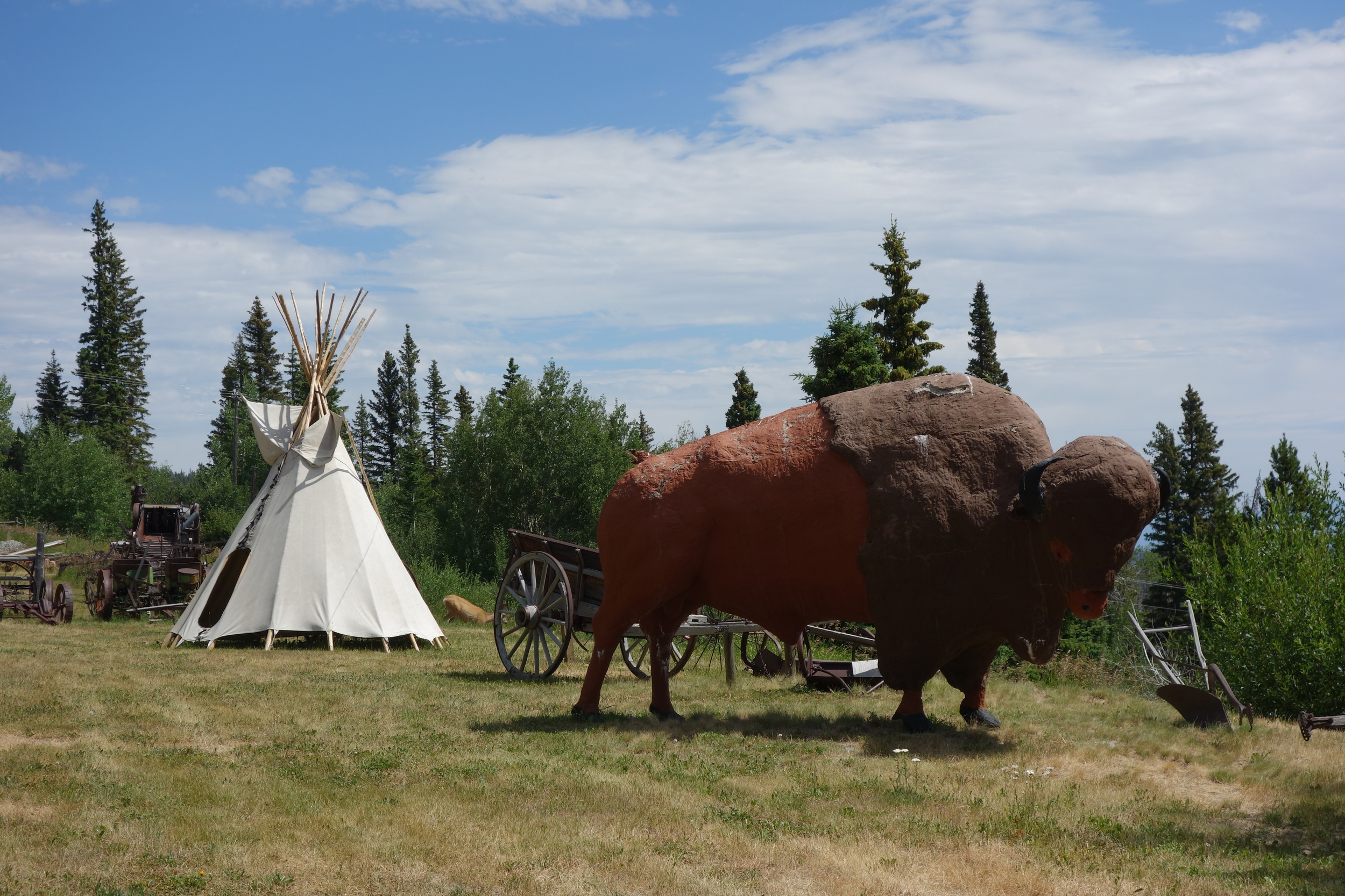
Within a mile of MacDonald Pass, Interstate 90, there’s a brief trail alternate. The note our dear cartographer, Ley, provides for the purple route mentions only that Frontier Town is no longer in business. Well, I sure as hell wasn’t going to skip seeing what would either be a ghost town or abandoned theme park, so Recon and I ducked a barbed wire fence after missing the initial turnoff. As soon as we came up the hill, between the massive buffalo statue and teepee, a doe bolted out of an empty garage across the road. I’d be hanging out there if I were a deer, too – shade all day long. I could describe the whole place, but instead I’ll just leave these photos here; they capture the vibe pretty well.


After about a half hour of unsuccessful hitching, one of the couples we had met collecting huckleberries pulled up on the shoulder and loaded us into their van. We went straight to a restaurant, naturally.